
The Nazca Lines: Peru's Enduring Desert Puzzle
Unexplained - ABikram Mondal
Etched into the Earth
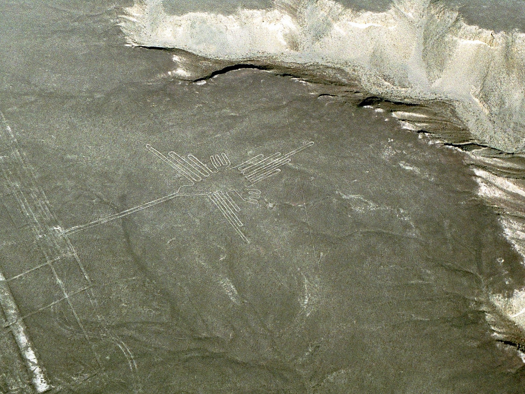
The Nazca plateau, a dry and stark expanse in southern Peru, holds one of the world's most enduring archaeological puzzles. For nearly a century, since commercial flights began to crisscross the region, pilots and passengers have gazed down at an astonishing sight: immense figures, geometric patterns, and straight lines etched into the desert floor. These are the Nazca Lines, and their sheer scale and precision are difficult to comprehend even today.
The lines are not carved deeply into the earth. Instead, they were created by removing the reddish-brown iron-oxide coated pebbles that cover the desert surface, exposing the lighter, gypsum-rich soil beneath. This simple technique, while effective, means the lines are shallow, often only a few inches deep. Yet, they have persisted for approximately 2,000 years, largely due to the region's hyper-arid climate and lack of wind.
The figures themselves are diverse. There are zoomorphic designs (hummingbirds, lizards, monkeys, pelicans, fish, and even a spider), phytomorphic designs (trees and flowers), and anthropomorphic shapes (often referred to as 'spacemen' due to their stylistic representation). Beyond these distinct figures, there are hundreds of geometric shapes (trapezoids, triangles, spirals) and thousands of straight lines, some stretching for many kilometres across the pampas. The most striking aspect remains their visibility: many of the larger designs are only fully discernible from an aerial perspective.
Who Made Them, and When?
The creation of the Nazca Lines is attributed primarily to the Nazca culture, which flourished in the region between roughly 100 BCE and 800 CE. Earlier geoglyphs in the area, often depicting more naturalistic human figures, are thought to have been made by the Paracas culture (around 800 BCE to 100 BCE), which preceded the Nazca. The sheer amount of labour and planning involved in their creation is significant, especially considering the lack of elevated viewpoints in the vicinity.
Archaeologists believe the Nazca people likely used simple surveying techniques. They would have made small-scale drawings first, then translated these onto the vast desert canvas using ropes, stakes, and perhaps astronomical observations. For the straight lines, it is proposed they used a system of sightlines between two points, extending them over distances. For the complex figures, a grid system or a series of radiating lines from a central point could have been employed. The precision, particularly in repeating elements or maintaining straightness over vast distances, speaks to a sophisticated understanding of geometry and planning.
The Enduring Question: Why?
Despite decades of research, the exact purpose of the Nazca Lines remains a subject of intense academic debate. No definitive answer has emerged, and various theories compete for acceptance.
One of the earliest and most widely known theories, popularized by Maria Reiche, a German mathematician and archaeologist who dedicated much of her life to studying and preserving the lines, suggested an astronomical calendar. Reiche proposed that many of the lines and figures aligned with significant celestial events, such as solstices, equinoxes, or the rising and setting points of certain stars. This theory posits the Nazca people used the geoglyphs to track agricultural cycles or religious festivals.
Another prominent theory connects the lines to water. The Nazca region is one of the driest places on Earth, and water was (and still is) a crucial resource. Scholars like David Johnson have argued that some lines point to sources of water or relate to underground aqueducts (known as puquios). Other interpretations suggest the lines were part of rituals designed to invoke rain or fertility, perhaps as pathways for ceremonial processions or offerings to deities.
More recently, a theory has gained traction that views the lines as ritual pathways or sacred spaces. Some researchers propose the figures themselves were not meant to be viewed from above by humans but were rather directed towards the gods, perhaps residing in the heavens or mountains. Certain lines appear to lead to specific sacred sites or ceremonial centres, reinforcing the idea of a ritualistic purpose.
New Discoveries and Modern Tools
In recent years, the understanding of the Nazca Lines has expanded significantly, largely thanks to advancements in technology. AI and drone technology have proven invaluable. For example, in 2022, researchers from Yamagata University in Japan, in collaboration with IBM Japan, utilized AI to analyze drone imagery and identify 168 new geoglyphs in the Nazca region. These discoveries add to hundreds previously found, bringing the total known geoglyphs to well over a thousand.
These newer discoveries often depict human figures, birds, cats, and snakes, and are generally smaller than the famous geoglyphs identified earlier. Many are found on slopes, suggesting they may have been intended to be viewed from below by local communities, or perhaps from nearby hills, rather than exclusively from the air. This challenges the long-held assumption that all Nazca Lines were solely for aerial viewing. The AI analysis helped distinguish subtle patterns that might be missed by the human eye, even with drone footage.
The continuous uncovering of new geoglyphs suggests that the full extent of the Nazca people's artistic and spiritual landscape is still being revealed. It also complicates the 'why' question, as a single, overarching explanation may not apply to all the different types of lines and figures.
Challenges and the Future
Despite their ancient resilience, the Nazca Lines face modern threats. Encroachment from illegal mining operations and unregulated development, particularly in areas surrounding the core protected zones, poses a serious risk to these fragile archaeological sites. Environmental changes, including increased rainfall due to climate change, also present challenges, as water can erode the shallow lines.
Conservation efforts are ongoing, with local authorities and international organizations working to protect these UNESCO World Heritage sites. The use of AI and remote sensing is not only for discovery but also for monitoring and mapping, helping to safeguard the existing lines from damage.
The Nazca Lines remain a profound testament to the ingenuity and spiritual depth of ancient cultures. They are a silent message from a long-vanished people, etched into the desert, waiting for us to fully decipher their meaning. What further secrets do these vast desert drawings still hold, hidden in plain sight?
Sources and further reading
- How hundreds of mysterious Nasca lines have been uncovered—with the help of AI - National Geographic
- We could soon solve the world’s biggest archaeological puzzle - BBC Science Focus Magazine
- Archaeologists use AI to discover 303 unknown geoglyphs near Nazca Lines | Peru - The Guardian
- 168 New Geoglyphs Discovered in Peru - Hyperallergic
- Nearly Half of the Protected Land Around the Nazca Lines of Peru Is Now Open to Miners - Smithsonian Magazine
- How AI Helped Decode Ancient Geoglyphic Etchings In Peru - analyticsindiamag.com
- Background reference: The Nazca Lines
A factual retelling drawn from public reporting on a real case. Where a claim is unproven, it is flagged. Please verify with the linked sources.